一.前言
由于最近在学习three.js,所以观摩了一下掘金,csdn等网站上的有关这部分的内容,刚好看到一个带你入门three.js——从0到1实现一个3d可视化地图 - 掘金 (juejin.cn),再加上我的专业属性是地理相关,可以说是专业对口,但文章已经是三年以前写的,而且没有在框架底下完成,有关three的很多API也发生了更改,所以我的思路是来自该篇文章,我进行了模仿和相应的修改,但是大致没有发生改变,可以说是站在前人的肩膀上。
二.预览

三.实现
首先就是开启一个vue项目,再npm install --save three,再引入一下d3就可以了,配置方面没有什么好配置的,这方面大家应该是没问题的。将代码写在子组件里,再引入到App.vue中展示就可以了。需要注意用到的全国的json数据来自DataV.GeoAtlas地理小工具系列 (aliyun.com)
子组件xx.vue对应代码
<template>
<div id="container" ref="canvasContainer"></div>
<div id="tooltip" ref="tooltip"></div>
</template>
<script setup>
import * as THREE from 'three';
//OrbitControls 是一个附加组件,必须显式导入
import { OrbitControls } from 'three/addons/controls/OrbitControls.js';
//墨卡托投影转换可以把我们经纬度坐标转换成我们对应平面的2d坐标,d3里面自带墨卡托投影转换
//该引入方式是查阅官网得到的
import * as d3 from "https://cdn.jsdelivr.net/npm/d3@7/+esm";
import { onMounted, onUnmounted,ref } from 'vue';
let canvasContainer = ref(null);
let tooltip = ref(null)
let scene,camera,renderer,ambientLight,raycaster,mouse;
let lastPick = null;
//初始化摄像机
function initCamera(){
camera = new THREE.PerspectiveCamera(75,canvasContainer.value.offsetWidth / canvasContainer.value.offsetHeight, 0.1, 1000);
camera.position.set(0,0,120);
camera.lookAt(scene.position);
}
//初始化renderer
function initRenderer(){
renderer = new THREE.WebGLRenderer();
renderer.setSize(canvasContainer.value.offsetWidth,canvasContainer.value.offsetHeight)
}
//初始化灯光
function initLight(){
ambientLight = new THREE.AmbientLight(0xffffff,20);
}
//加载json数据
function loadJson(){
const loader = new THREE.FileLoader();
loader.load('src/assets/中华人民共和国.json',(data)=>{
const jsondata = JSON.parse(data);
generateGeometry(jsondata)
console.log(jsondata);
})
}
// 根据JSON数据生成地图几何体
function generateGeometry(jsondata){
let map = new THREE.Object3D();
// 使用d3的地图投影
const projection = d3.geoMercator().center([104.0,37.5]).translate([0,0]);
// 遍历每个省份,创建几何体
jsondata.features.forEach((element)=>{
let province = new THREE.Object3D();
const coordinates = element.geometry.coordinates;
if(Array.isArray(coordinates[0][0][0])){
coordinates.forEach((multiPolygon)=>{
multiPolygon.forEach((polygon)=>{
const shape = new THREE.Shape();
const points = [];
polygon.forEach((coord,i)=>{
const [x,y] = projection(coord);
if(i===0) shape.moveTo(x,-y);
else shape.lineTo(x,-y);
points.push(new THREE.Vector3(x,-y,5));
})
const lineGeometry = new THREE.BufferGeometry().setFromPoints(points);
const lineMaterial = new THREE.LineBasicMaterial({ color: 'white' });
const line = new THREE.Line(lineGeometry, lineMaterial);
const extrudeSettings = { depth: 10, bevelEnabled: false };
const geometry = new THREE.ExtrudeGeometry(shape, extrudeSettings);
const material = new THREE.MeshBasicMaterial({ color: '#2defff', transparent: true, opacity: 0.6 });
const material1 = new THREE.MeshBasicMaterial({
color: '#3480C4',
transparent: true,
opacity: 0.5,
})
const mesh = new THREE.Mesh(geometry, [material,material1]);
province.properties = element.properties;
province.add(mesh);
province.add(line);
})
})
}else if(Array.isArray(coordinates[0][0])){
coordinates.forEach((polygon)=>{
const shape = new THREE.Shape();
const points = [];
polygon.forEach((coord,i)=>{
const [x,y] = projection(coord);
if(i===0) shape.moveTo(x,-y);
else shape.lineTo(x,-y);
points.push(new THREE.Vector3(x,-y,5));
})
const lineGeometry = new THREE.BufferGeometry().setFromPoints(points);
const lineMaterial = new THREE.LineBasicMaterial({ color: 'white' });
const line = new THREE.Line(lineGeometry, lineMaterial);
const extrudeSettings = { depth: 10, bevelEnabled: false };
const geometry = new THREE.ExtrudeGeometry(shape, extrudeSettings);
const material = new THREE.MeshBasicMaterial({ color: '#2defff', transparent: true, opacity: 0.6 });
const material1 = new THREE.MeshBasicMaterial({
color: '#3480C4',
transparent: true,
opacity: 0.5,
})
const mesh = new THREE.Mesh(geometry, [material,material1]);
province.properties = element.properties;
province.add(mesh);
province.add(line);
})
}
map.add(province);
})
scene.add(map);
}
// 设置光线投射器和鼠标位置,用于检测鼠标悬停对象
function setRaycaster(){
raycaster = new THREE.Raycaster();
mouse = new THREE.Vector2();
const onMouseMove = (event) => {
mouse.x = (event.clientX / canvasContainer.value.offsetWidth) * 2 - 1
mouse.y = -(event.clientY / canvasContainer.value.offsetHeight) * 2 + 1
tooltip.value.style.left = event.clientX + 2 + 'px'
tooltip.value.style.top = event.clientY + 2 + 'px'
}
window.addEventListener('mousemove', onMouseMove, false)
}
// 显示或隐藏工具提示
function showTip(){
if(lastPick){
const properties = lastPick.object.parent.properties;
tooltip.value.textContent = properties.name;
tooltip.value.style.visibility = 'visible';
console.log(tooltip.value.textContent);
}else{
tooltip.value.style.visibility = 'hidden';
}
}
// 动画循环,用于渲染场景和更新状态
function animate() {
requestAnimationFrame(animate);
raycaster.setFromCamera(mouse,camera);
const intersects = raycaster.intersectObjects(scene.children,true);
if (lastPick) {
lastPick.object.material[0].color.set('#2defff')
lastPick.object.material[1].color.set('#3480C4')
}
lastPick = null
lastPick = intersects.find(
(item) => item.object.material && item.object.material.length === 2
)
if (lastPick) {
lastPick.object.material[0].color.set(0xff0000)
lastPick.object.material[1].color.set(0xff0000)
}
showTip();
renderer.render(scene, camera);
}
//窗口大小改变时,更新摄像机的宽高比和渲染器的大小
function handleResize(){
if(camera && renderer && canvasContainer.value){
camera.aspect = canvasContainer.value.offsetWidth / canvasContainer.value.offsetHeight;
camera.updateProjectionMatrix();
renderer.setSize(canvasContainer.value.offsetWidth, canvasContainer.value.offsetHeight);
}
}
// 组件挂载时的初始化逻辑
onMounted(()=>{
scene = new THREE.Scene();
setRaycaster();
initLight();
scene.add(ambientLight);
initCamera();
loadJson();
initRenderer();
canvasContainer.value.appendChild(renderer.domElement);
new OrbitControls(camera,canvasContainer.value)
animate();
window.addEventListener('resize',handleResize)
})
onUnmounted(()=>{
window.removeEventListener('resize',handleResize)
})
</script>
<style>
body{
margin: 0;
padding: 0;
overflow: hidden;
}
#container{
/* border: 1px solid black; */
width: 100vw;
height: 100vh;
}
#tooltip {
position: absolute;
z-index: 2;
background: white;
padding: 10px;
border-radius: 5px;
visibility: hidden;
}
</style>
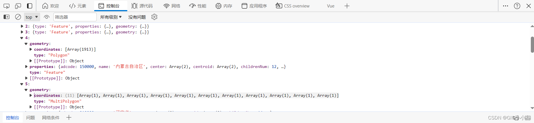
注意在用JSON数据生成地图集合体时分两种情况是因为:
不同省份数据数组嵌套的层数不一样,类似于下面这两地
共勉,如果对于实现的步骤还有疑惑,可以转至我在前言分享的那篇文章 ,它对于实现步骤更详细,可以结合着看。
————————————————
版权声明:本文为博主原创文章,遵循 CC 4.0 BY-SA 版权协议,转载请附上原文出处链接和本声明。
原文链接:https://blog.csdn.net/weixin_73810008/article/details/136403181
文章
11.75W+人气
19粉丝
1关注
更多数字孪生可视化干货内容


 扫一扫关注公众号
 扫一扫联系客服
©Copyrights 2016-2022 杭州易知微科技有限公司 浙ICP备2021017017号-3  浙公网安备33011002011932号
互联网信息服务业务 合字B2-20220090